
By the time we
got the car secured on the dolly it was 10:30 and we were on our way south. It
was foggy and got foggier as we traveled past the harbors heading to US 1. We traveled about 120 miles south through interesting
little coastal towns … which was probably beautiful… if we could see it! Went across a very tall bridge which probably
had a beautiful view …. if we could have seen it!
Arrived in Shore
Hills Campground outside of Boothbay Harbor around 3:00 and as we were checking
in, I saw the weather forecasts on the TV.
Looked like the mid-coast section
(PA,NY) was getting some baaaaaad weather.
We were starting to get the effects of the winds and were expecting some
rain as the storm moved through New England.
Sunday,
September 9th. Weather was
overcast but not rainy so we decided to scope out the area. We’re about 10 minutes from Boothbay and
picked up some material and maps at the Information Center just down the road
from the CG. We drove down through the
town out Rte 96 which took us around Ocean Point.

RAM ISLAND LIGHTHOUSE
Just as we were
heading out of Boothbay we came to a very scenic spot … lo and behold … a
lighthouse! Ram Island Lighthouse located
on the northern tip of Fisherman Island on the southside of Fisherman Island
Passage.
In the mid-1800’s a
fisherman, after escaping the dangerous rocks near the island, hung a lantern
at night for the benefit of local fishermen.
The fisherman left the area after a number of years and the lantern was
kept by a second keeper then a third.
The third
lantern keeper anchored a dory and rigged the lamp on its bow. The last fisherman coming into the harbor
each day was to light the lantern. Unfortunately,
the dory was smashed in a storm.
The lone
resident of Fisherman’s Island maintained a lantern but it wasn’t bright enough
and there were more wrecks. Once when a
schooner was in danger of coming up on
the rocks the fisherman got a line to the vessel and the crew managed to escape
to shore. Other wrecks caused most of
the crew to be killed.
After this, there
was no light on Ram Island but the ghosts seemed to fill in quite nicely!
Locals talked of
ghosts warning vessels away from dangerous rocks. In Lighthouses
of the Main Coast and the Men Who Keep Them by Robert Thayer Sterling, one
captain swore he was warned by a fog whistle at Ram Island during a snowstorm;
another saw a burning boat on the rocks and changed direction. Of course no fog whistle was on the island
nor was there evidence of a burning boat the next day. One sailor saw a woman in white waving a
torch over her head and the sailor veered off before hitting the rocks. A schooner helmsman claimed a bolt of
lightning illuminated the area moments before his vessel would have struck the
rocks.
In 1882 Congress
appropriated $25,000 for a lighthouse and it went into service in 1883. The first keeper was Samuel John Cavanor who
stayed until he died in 1913 on the island.
Cavanor had a wooden leg. He, his
wife May and their five daughters lived on Ram Island.
During his first winter, a severe hailstorm
broke the lantern glass and the lamp was blown out. Cavanor tried to keep the light going thru
the night by shielding it with newspapers.
There were many, many storms, gales and wrecks through the years he was
keeper. The keeper’s house was at the
top of the island and the lighthouse was a distance away on water level
connected by a bridge. It sits on the
inner side of the island lighting the entrance to Boothbay.

Came back up Rte
96 and over to Southport Island driving the loop. The views kept getting better and
better.

HARBORS, INLETS, HOUSES ON THE HILLS


Headed over to Southport Island and drive the perimeter. Again, the views just kept coming. Met two couples sitting on the dock ..... one has a summer home in Boothbay and a winter home in (wait for it) Port Orange..... and the other one lives in Canada and has a winter home in Boca Grande FL. The Canadian couple asked if we were "snow birds". I responded, "No, we're migratory (according to my lawn man). We leave May-Oct .. like the birds?"
WE'RE EVERYWHERE............................

This little harbor has several islands off the mainland. Wouldn't you love to live on an island??

Entering the area is .. dodge the rocks

..or ... Dodge the Buoys!

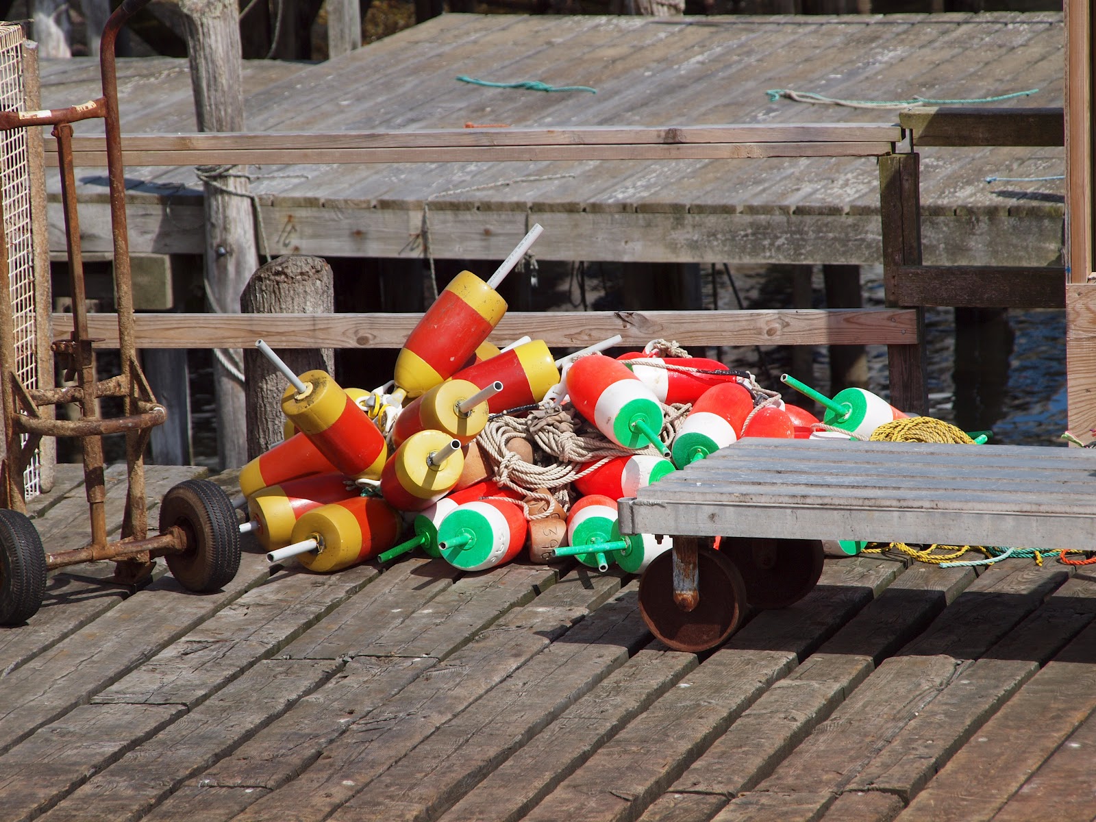
BUOYS .. OH
BUOY!
There is an
unforgiving triumvirate when cruising Maine; rocks, fog and lobster buoys. Most of the rocks are charted, the fog comes
and goes (sometimes), but these brightly painted lobster buoys are everywhere! (and I don't mean just hanging on the sides of buildings).
Over three million lobster traps are fished
in Maine waters. Each buoy is attached
by the potwarp (a long line) and then attached to one or more traps (pots) weighted
to the bottom. The issue is not in
hitting the buoy as it may pop out in the surface of your wake, but when the
prop catches the potwarp and wraps around the shaft. This becomes even more critical when it’s
night, foggy or in an exposed location with hard currents or heavy traffic.
Most of the
boats have a cage around the propeller or Spurs or other cutting devices on the
shaft.
Neither is a great solution so
the best solution is to bob and weave through the mine field that is lobster pots.

HENDRICK’S HEAD LIGHTHOUSE
Off in the
distance we could see Hendrick’s Head Lighthouse sitting off the coast. This lighthouse was built in 1829 to guide
vessels up Sheepscot River to Wiscasset Harbor.
Jaruel Marr was appointed the lighthouse keeper in 1866 for compensation
for injuries sustained fighting the Civil War.
He walked 60 miles to Portland to enlist in the Union Army; was wounded
and incarcerated in a Confederate prison in Virginia.
During Jaruel
and his wife’s Catherine’s stay, in 1870 a schooner ran aground on the rocky
ledge seaware of the lighthouse. Unable
to launch their dory due to the turbulent waters, the crew clamored up the
rigging of the doomed vessel which was soon broken to pieces by the towering
waves. Jaruel built a bonfire on the
shore in hopes to finding survivors. He
noticed a bundle buffeted by the waves, waded out and saw it was a pair of
feathered mattresses around a box.
Inside the box was a screaming baby girl. The baby girl was later adopted by summer
residents of the area and was named Seaborn.
In 1933 the
light was replaced by an offshore buoy.
In 1991 the 4
½-acre lighthouse property was purchased and completed restored. The fixed white light with red sectors
continues as an active aid to navigation.
We spent some time walking around the downtown area. It is a very pretty town with the steep streets meeting at angles with the harbor. You have to be careful to understand who has the right of way driving on the streets. In a lot of ways, Boothbay Harbor is prettier than Bar Harbor; the shops are more interesting and the buildings are more interesting. Not only that ..... lobster is cheaper here! In fact, most food is cheaper here.
We went back to the MH to get cleaned up and drop of Billy so that we could head back down to the harbor for dinner. Dave had twin lobsters (for $20) and I had clam roll (clams with bellies). It was a lovely evening eating out over the water. The front was passing through with the nice weather right behind it.
We headed down to the harbor to pick up some ice cream for our dessert. It was a great night!
September 10th - we decided to take a look at a lighthouse.

PEMAQUID POINT LIGHTHOUSE
Pemaquid Point Lighthouse is located in Bristol, Me (one peninsula over but had to go back up US 1 and down to get to it).
Pemaquid Point
Lighthouse is the first land-based lighthouse opened to the public. You can get married here, spend your
honeymoon here and pay it with US money that bears the image of the lighthouse –
Maine’s official quarter!

The lighthouse was commissioned in 1827. At first the light burned sperm whale oil but later went to kerosene. The lighthouse was automated in 1934 fueled by gas.

The tower stands 30' tall and the lantern is 48' above the ground and 79' above sea level.

The fog bell was installed in 1897 using a Stevens striking machine. The keeper would wind up the machine bringing the weights to the top of the tower. The bell rang at regular intervals for six to eight hours as the weights slowly descended .... like a cuckoo clock. Now there is a gong buoy moored off west of the point.

HURRICANE LESLIE
Hurricane Leslie was off the coast (way off) but creating some wonderful surf to watch.

Is there little wonder that shipwrecks were so common on this rugged coast.
Between the Maine's rocky coast and harsh weather, many sailing vessels ended up on the rocks or at the bottom of the ocean. Pemaquid Point's sharp rocks divide from the west the entrance to Muscongus Bay and the east to the opening of Johns Bay.

The most famous shipwreck, Angel Gabriel, was a galleon carrying about 100 English settlers and provisions Before it was fully unloaded an August 1635 hurricane sunk the boat along with four or five people and all of the passengers belongings.

In September 1903 a mackerel seiner out of Gloucester, MA went ashore on the eastern side of Pemaquid attempting to make the point. Wind increased to hurricane strength and the fishing schooner was helpless on the rocks. Dory after dory was put over the side and smashed to bits in the surf. Of the sixteen men aboard, fourteen (including the Captain) drowned. The two survivors struggled in the boiling sea and made it to shore.

In August 1917 in heavy fog a two-masted schooner Willis and Guy struck the rocks near the lighthouse point. The crew of three were saved but a hurricane four days later completely destroyed the vessel. Her cargo, coal, was scattered over the rocks. Area townspeople came down to the rocks and salvaged enough coal to heat their homes the following winter.

The waves crashing against the rocks lulls one into thinking they are safe on the upper rocks. That is not so. Waves came in at erratic sets; one set could appear fairly mild, then there would be a build up and a series of waves building on each other would crash into the rocks. Tides can sneak up on observers. In 1991 a swell engulfed a 37 year old man and in 1994 a father and son narrowly escaped a giant wave. I imagine that happens pretty often, hopefully without fatalities.

The rocks at Pemaquid Point fall into three main categories: granite, gneiss and tilted layers.

Imagine that 200 million years ago the molten lava rose up from the earth's core, hardened, then 20,000 years ago the glaciers started moving down from Canada, across Vermont, New Hampshire and Maine pushing rocks forward all the way down to Cape Cod, MA.

The scratches on these rocks are engravings from the glaciers as they picked up rocks and pushed them forward scratching the surfaces of the land.


This area gets upwards of 100,000 visitors a year. Many artists have come out here to enjoy the magnificent views and wonder of the the powerful seas.

The area was captivating and we spent several hours walking around the park, lighthouse and the rocks. Hunger finally struck and we went in search of an outdoor restaurant on the water. Drove over to New Harbor to have lunch on the dock at Shaws.


Hopefully tomorrow the winds will be down and the seas will be down and we can catch a ferry to Mohengan Island. If not....we've got other options

Is there little wonder that shipwrecks were so common on this rugged coast.
Between the Maine's rocky coast and harsh weather, many sailing vessels ended up on the rocks or at the bottom of the ocean. Pemaquid Point's sharp rocks divide from the west the entrance to Muscongus Bay and the east to the opening of Johns Bay.

The most famous shipwreck, Angel Gabriel, was a galleon carrying about 100 English settlers and provisions Before it was fully unloaded an August 1635 hurricane sunk the boat along with four or five people and all of the passengers belongings.

In September 1903 a mackerel seiner out of Gloucester, MA went ashore on the eastern side of Pemaquid attempting to make the point. Wind increased to hurricane strength and the fishing schooner was helpless on the rocks. Dory after dory was put over the side and smashed to bits in the surf. Of the sixteen men aboard, fourteen (including the Captain) drowned. The two survivors struggled in the boiling sea and made it to shore.

In August 1917 in heavy fog a two-masted schooner Willis and Guy struck the rocks near the lighthouse point. The crew of three were saved but a hurricane four days later completely destroyed the vessel. Her cargo, coal, was scattered over the rocks. Area townspeople came down to the rocks and salvaged enough coal to heat their homes the following winter.

The waves crashing against the rocks lulls one into thinking they are safe on the upper rocks. That is not so. Waves came in at erratic sets; one set could appear fairly mild, then there would be a build up and a series of waves building on each other would crash into the rocks. Tides can sneak up on observers. In 1991 a swell engulfed a 37 year old man and in 1994 a father and son narrowly escaped a giant wave. I imagine that happens pretty often, hopefully without fatalities.

The rocks at Pemaquid Point fall into three main categories: granite, gneiss and tilted layers.

Imagine that 200 million years ago the molten lava rose up from the earth's core, hardened, then 20,000 years ago the glaciers started moving down from Canada, across Vermont, New Hampshire and Maine pushing rocks forward all the way down to Cape Cod, MA.

The scratches on these rocks are engravings from the glaciers as they picked up rocks and pushed them forward scratching the surfaces of the land.


This area gets upwards of 100,000 visitors a year. Many artists have come out here to enjoy the magnificent views and wonder of the the powerful seas.

The area was captivating and we spent several hours walking around the park, lighthouse and the rocks. Hunger finally struck and we went in search of an outdoor restaurant on the water. Drove over to New Harbor to have lunch on the dock at Shaws.


GOTTA GET ME SOME BUOYS!!!!!
Hopefully tomorrow the winds will be down and the seas will be down and we can catch a ferry to Mohengan Island. If not....we've got other options
Stay tuned!


No comments:
Post a Comment