....WITHOUT OBAMA OR ROMNEY!
We got an early start … around 11AM …. Packed up and headed
east. Stopped in Ascutney to fill up
propane and hit I91 north to the
Presidentials. The ride up was
beautiful, just as we had expected it to be in this part of God’s country, but
still wide-eyed and amazed at the beauty that is Vermont. Around St Johnsbury we headed East on I93
toward Littleton NH and then Route 2 toward Gorham. This is where it got dicey as can only be
appreciated if you’re driving a 35’ motor home towing a car (backwards) behind
it.
THE ROAD OF NO RETURN……….
One set of directions said to turn right on Pinkham Road
whereas the TomTom said to continue on past Pinkham. TomTom had also routed us way south so we
decided to go with Google directions, making a fast right on Pinkham Road
despite the lack of signs for Dolly Copp Campground, one of the largest in the
US Forest Service. That should have been
our first clue … and I actually remember mentioning it but not going further
with the concern. Of course, that could
be because we were on the road of NO RETURN!
No way in hell were we going to be able to turn around and
go back … even if we disconnected the car … had no choice but to preserve and
move forward.
We drove from rough blacktop to no blacktop and a sign that
said, “Road not maintained in the winter”.
I don’t think it’s maintained in the summer either. There was no shoulder .. hah! .. and the
dirt road exact width of our wheel base just fell off into large holes that
would have turned us on our side or grabbed the dolly and done bad things to
that! I kept leaning to my left as if
that would make the MH go away from the side of the road.
We continued on and on and on and on …. through the White
Mountains National Forest … then…. we started meeting cars coming from the
other direction. Fortunately they were
able to squeeze over and let us by. I
saw hiking trails going off from the left and right so figured that’s what the
road was used for. Come to find out it’s
also used as a “cut through” by locals who have the correct vehicles to cut
through!
We were on this climbing, rough dirt road for several miles
in the hope it came out somewhere. About
5 miles we came to black top. Turn right
… entrance to Dolly Copp Campground.
Turn left … Route 16. Much easier
way to get to the park!
Got to the Ranger’s Hut to check in .. along with the
“throngs of thousands” of other campers doing the same thing. Of course I had no paperwork since I don’t
have the printer hooked up to my computer, and this campground does everything manually. No computers here! No credit cards, cash only for those who had
too many cars or too many people than they paid for. If I didn’t know my campsite number, my
choice was to go back and hope I could get internet and find the reservation or
go through the list of over 100 campsites and find our name.
I opted for the computer hoping we had a bar of signal and
we did! Site 48. I was in.
Went back to the hut, to the back of the line, and waited for our turn
to check in. While waiting saw pictures
of black bears that frequent the campground picking up the apples from the
numerous apple trees here. We were given
a slip on “how to behave around bears”….all food inside, don’t run away, talk
gently to them….not worried. We got them
in VT too.
The CG Host was very efficient having to write the same
thing in three different places and I asked if they were the volunteer
hosts. She said they were and I told her
we were hosting in Vermont for the summer.
Got a big smile and welcome to the campground. We have a sisterhood!!
The campsite is very nice, the campground is great. We didn’t have any problems backing in and
setting up. Very easy when you don’t
have utilities. Sat down with a beer and
read the “Dolly Copp News”. Apparently
there are no hot showers here. You have
to drive to the visitors center five miles down the road for a hot shower …
bring quarters. No worries … we brought
our own.
No dump station. If
we want to empty our tanks, we need to drive to the sanitation center in Gorham
and for a fee can relieve our tanks.
Hopefully Acadia will have a dump station when we get there.
Didn’t get to see too much as it was late in the afternoon
and thunder was heard in the distance.
Came inside for a short nap and it poured. Haven’t had a thunder storm in a long
time. It rained and rained and
rained. Continued to rain into the
evening and off and on all night.
So……we’re camping in the rain …. Whatelse is new! Dragged the picnic table under the awning and
fired up the grill. Not sure how long it
will last but it’s dark and still raining.
All is good!
THE NOTCHES
9/1/12

THE IMP!
This morning was bright and
beautiful but the clouds were still hanging low from last night. We decided to drive down past Mt Washington to
North Conway over the Kamcamagus Highway through Franconia Notch, up Route 3 to
302 through Crawford Notch. As we passed
Mt Washington the clouds were still hanging low on top of him.
Driving down through the
small towns to North Conway we passed Pinkham Notch Visitors Center where
thousands of cars were parked, filling up the parking lots and parking along
the roadway. We decided to skip
that! I know it’s Labor Day Weekend so
expected crowds but there are A LOT OF PEOPLE up here this weekend, mostly from
Massachusetts and Rhode Island. Guess it’s
a straight shot up the Interstate out of Boston.
The towns we drove through were crowded and
touristy. There’s Story Land, Santa
Land, North Pole, South of the North Pole, Santas Village, Cog Railroad, Crawford Notch Railroad, Hobo Railroad, water parks … you name it, it’s
got it. Reminds me of Gatlinburg, TN!
I know we were in the more popular areas so I
don’t want this to be a generalization of New Hampshire. I’m sure there are spots in NH that are
remote, prestine and quiet. Just not on
Labor Day Weekend.
We also were on some of the
most popular drives. I must say I was
happy to be heading south from Gorham to North Conway and over because the
traffic coming from the south into Conway towards Mt Washington was
bumper-to-bumper going the speed of a parking lot in gridlock! We at least were moving.

WHITE MOUNTAIN VISTAS

DRIVING FRANCONIA NOTCH!

Kancamagus Highway cuts a 34
mile east-west channel through the White Mountain National Forest from Conway
to Lincoln.
Plenty of motorcyclists on
the road as they twist and turn climbing almost 3,000’ at the peak of Mount
Kancamagus and hugging the center line! With cyclists on your right, and motorcycles taking their half out of the middle, it made for some adventurous driving. Dave was snuffing through his nose most of the way!

OLD MAN OF THE MOUNTAIN isn't anymore ... he fell off!
Trailheads beckoned but the
parking lots were overflowing and I figured we’d be waiting in line to scramble
the next rock. That might not be a bad
thing … more to hang on to!

The views were
breathtaking. We stopped in Crawford
Notch State Park for a picnic where the Flume was, but didn’t go down (again
all parking lots full) because we had Billy.
Every campground we passed had FULL as this entire region is occupied
with campers.
In Lincoln we took Route 3
north to 302 across Crawford Notch to get us back south of Mt Washington and North
of Conway. Again, magnificant views.
Coming up from the east of Mt Washington was MOUNT WASHINGTON HOTEL.

In 1902 this was one of the largest and
most modern grand hotels in the White Mountains. Served by 57 trains a
day, the Mount Washington Hotel became known as one of the most luxurious
summer resorts in the United Stated. It
was designated a National Historic Landmark in 1986.
The BRETTON WOODS MONETAY CONFERENCE was held here July 1944. Convened by allied nations before the end of WWII and it was attended by representatives of 44 countries. Bretton Woods Conference established regulations for international monetary system following the war. The conference created the International Monetary Fund and future World Bank and linked the exchange rate of world currencies to the value of gold.
I wonder if the hotel takes dogs????

Came down through Crawford Notch winding through back to Route 16 up to Mt Washington and Dolly Copp CG.
SEPTEMBER 2, 2012
A CLIMB INTO THE CLOUDS

Woke up to rain again this morning. This is the second morning it has rained
without any predictions … how dare! Not
following the rules!
Eventually it cleared up enough that we decided to head to
Mount Washington for our last day in the Presidentials. When we got to the roadway, the top of Mt
Washington and others were in the clouds.

We started our climb in low gear; forecasts were 53 degrees
with 30 kts wind at the top. As we
climbed and climbed, the vistas started to appear. At first they were simply white then the
clouds started to move and we could see glimpses of mountains peaking through
the clouds.

You had to move fast, however. As soon as I took a shot and looked down at my camera to adjust a setting, the mountain disappeared!

The road got windier and narrower with the sides wide open
and no guard rails. I found myself
gripping the door and smashing my foot into the floor … for what, I don’t
know. Finally talked myself into
relaxing as there wasn’t anything I could do from my side of the car.


So then I just closed my eyes but thought I probably should keep them open in case I had to brace myself. On and on these thoughts came through my head as we climbed higher, steeper, cloudier and then … the pavement ran out! Oh joy! Now it was dirt packed with no shoulder on either side … wall of rock on one side, nothing on the other.

LOOKING DOWN AT WHERE WE CAME FROM FALLING OFF INTO THE CLOUDS!
Fortunately there were pullovers so that I could catch a
view if there was one and catch a breath if I had one!

Got to the top. The clouds were swirling but for the most part they were under us.


Walking through the clouds we went up to the
observation deck and looked at the vistas as they came and went, went and
came! Hikers were arriving from
somewhere or getting ready to head out somewhere.

CHECKING TRAIL MAPS ... WHERE DO WE GO?????
The two in front of us climbing the stairs looked much the
worse for wear. The guy was gasping as
he climbed these stairs as though the stairs were harder than the rock
scrambles he probably had just finished.

All kinds of languages spoken at the top. Guess this is an international
destination. No one particular group
stood out, just lots of different chatter all around.

Cameras ready ... everyone is grabbing a view!
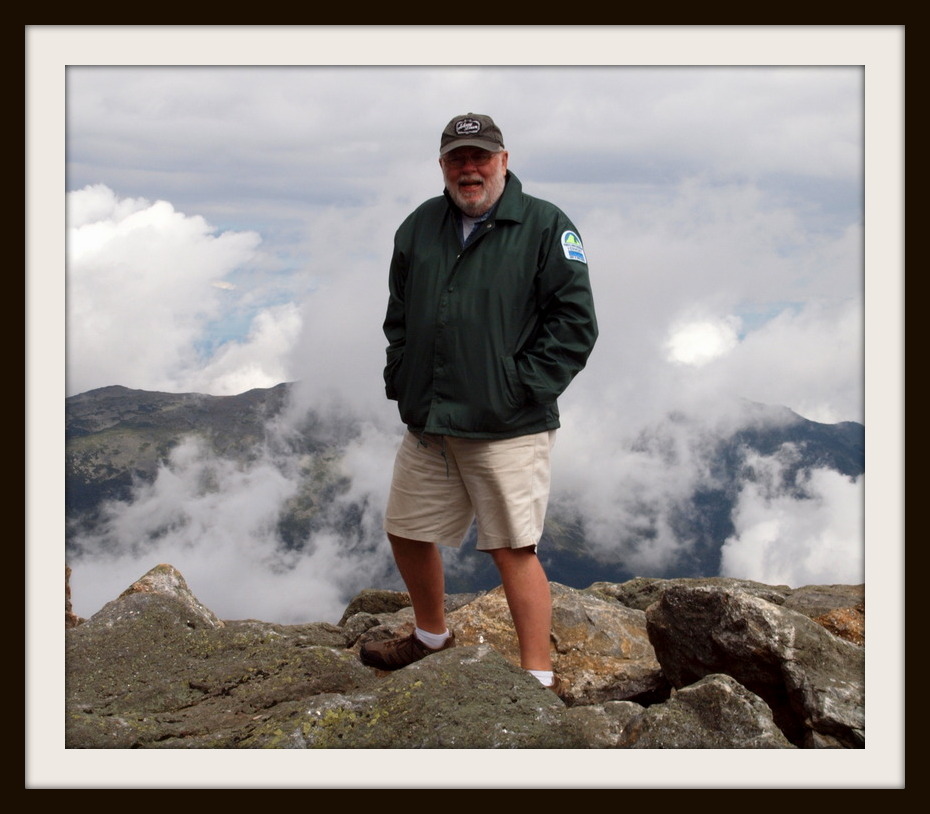
Does he look cold??

Mount Washington has some of the severest weather ever recorded. The weather station up there is manned all year and there were videos of the different weather events that have happened at the top.


One minute the tower's there ...... the next it's gone!

As we were getting ready to head back down the cog train
arrived dropping off passengers and picking new ones up. I imagine the ride down in the front of the
first car must be a thrill as it looks like the tracks go right over the edge
of the mountain.


We headed down and the clouds were clearing as we went. It wasn't any easier going down than coming up ... except we could see better .... I guess that's something to be thankful for.


It was a balmy 65 degrees at the bottom so
the layers of jackets came off.
THE BROTHERHOOD THAT IS NATURE
We stopped at Burger King in Gorham for a quick lunch so
that we could include Billy. He feasted
on my French fires and fried chicken sandwich.
There was a young kid (early 20’s, maybe) sitting outside with all
of his backpacking gear spread out on the lawn to dry in the sun. I asked him if he had climbed the mountain
today, and he said he had climbed many mountains. I asked him where he was going next and he
shrugged and said he was heading up to
Maine.
I asked if he was
doing the Appalachian Trail and he said he was.
"Where did you start?
“Springer Mountain”.
“Dahlonega?” I asked.
He smiled, “Yes, at the trailhead”.
“I hiked the AT at that trailhead also, spun off onto the Betton
McKay. (probably before he was born!) My name’s in the AT log book kept in a rock at
the trailhead.”
He smiled, “Yeah! Mine too!"
" I picked up a hiking stick on the trail and used it for 20 years hiking all over
the place until it finally formed a crack up the side so switched to trekking
poles. The hiking stick is special to
me."
He showed me a very handsome, sturdy hiking stick he also picked
up alongside a brook on the trail. Gnarled and bent beautifully to fit his hand as mine has done.
He was very happy with his hiking stick. It
will last him at least twenty years.
He wished us safe travels and we wished him safe travels.
Some things stand the test of
time. People have been walking this
country since the early pioneers and the tradition continues to grow stronger
and stronger.

THE PRESIDENTIALS ARE MAGNIFICANT!
OFF TO THE MAINE COAST TO CHECK OUT THE LIGHTHOUSES AND LOBSTERS!
STAY TUNED

No comments:
Post a Comment