HERKIMER NY is 13 miles from Utica in what is known as
the Mohawk Valley at the entrance of the Adirondacks. We are staying at the
KOA and the Canada River is right in front of us. White water kayakers came by in several
groups.
Originally settled by Germans the area became known as
“German Flatts”. During the French and
Indian War (George’s other war), Herkimer suffered one of the most terrible
massacres recorded in colonial period. Herkimer extends along the Mohawk river
connecting the Atlantic Ocean with the interior of North America.
Nature bestowed upon NYS the only low level,
natural opening through the Appalachians between Georgia and Maine – the Mohawk
Valley. This was key to building the Erie
Canal.We took an Erie Canal cruise down the Mohawk River from Herkimer NY which took us through Lock 18 dropping us 20 feet . Lock 18 is listed on the National Register of Historic Places and is one of the most historically correct locks on the canal.

It was curious that this boat came out of Fort Lauderdale FL where there are several water taxis. Dave gave it a good once over to see if it was built in Tavares like the NSB Water Taxi was.

Captain Dave giving it the Coast Guard Inspection!
Everything on the canal can be worked without electricity and much is original equipment used for the past 100 years. Canal was completed in 1825.

Erie Canal Lock E-18 is located at the east end of a land cut that avoids an un-navigable section of the Mohawk River and something called "Knock Em Stiff Rapids". At this point the Mohawk River flows to the left and the land cut is to the right.

The canal is closed in the winter. This dam, which can be lowered by hand or have a generator brought in on a truck, is used in the winter to divert the water from the land cut down the Mohawk River. It can also be used during high waters and flooding to divert the water. During the winter, the land cut we traveled on has a trickle of water down the middle, otherwise is muddy and dry.

The first canal was dug almost entirely by hand. It was 40’ wide by 4’ deep and ran 363 miles across state from Albany to Buffalo with 83 locks. The locks raised vessels 565’ between those two cities.

First barges were pulled by mules or horses along towpaths.

Second oldest surviving church in NY State at what was known as Fort Herkimer The Canal was the first serious route for settlement west of the Appalachian Mountains

Next to the lock is this spillway to control the water level in case of floods. You can walk down the lawn to the natural Mohawk River which is 20' below.
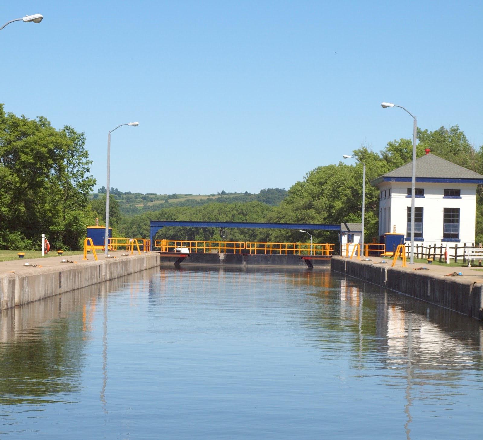
The white building at the lock is used for general storage however it once housed the electric generators used to work the lock. The little shack in the front of the Power House contains the lock controls.


Nex to the T2 is the Buoy boat. I think his job is self explanatory.
Since we're dropping 20', the lock is full of water.

The doors
to the locks are a mitred Vee so do not
close flush. This design was used in the
1500’s and has not changed. When the lock
fills up, the water forces the doors closed and prohits the other doors from
opening. The water must drop below the
doors before the doors will open. A
proven design after all these years.

The pressure of the water is what stabilizes the doors.
Waiting on the other side of this lock, to be raised up 20', was a Looper from Canada. Dave and I figured they are probably on their way home from Florida or the Bahamas and will duck out of Oswego into Lake Ontario.


On this side of the lock, the land cut ends and the Mohawk River continues on.

Once through the Lock we turned around and joined the Canadian Trawler as the water filled up the lock and we were lifted 20' up. The water comes into the lock through valves or ports located throughout the lock. You notice immediately when the water is flowing in as it forms pools all along the lock. Going down is like an elevator but coming up can be a little rough so it's important to be secured to the side.

I watched carefully to see what the boat was attached to. There are cables that run perpendicular in the canal. You can attach a loop around the cable that will slide with the boat. Also there are lines along the side that can be thrown down the side of the canal walls and you can grab those. I noticed the trawler in front of us must have been using their own lines on the cable as I did not see any lines dropped down the side.
The Erie Canal is wholly owned by the State of New York. It is managed by the Erie Canal Commission and run by the NY Thruway Comission. When doing the loop, a boater would purchase a pass which would cover all locks. The largest boat’s fee is $100 and it goes down from there. Not a bad value.
Interestingly, the Canal
speeds are not enforced. Rarely are there officals on the water and if so, they are checking for fishing licenses. This according to our Captain. It may be different on other parts of the canal.
The speed limit on the river is 15 mph. As a boat goes through the lock,
the lock tender radios ahead to the next lock letting them know that a boat
should be arriving by a certain time (if keeping within the speed limit). If the boat arrives early it is evidence he
sped and will have to sit and wait until the time he was supposed to arrive to
go through the locks. They have their
ways!
Today the Erie Canal is a yacht highway and that is the revenue the Canal Commission is looking for. The actual tolls paid do not touch the maintenance costs. However the collateral effect on the surrounding towns that the Looper business brings in is wonderful.
The NYS Canal Corporation and Erie Canalway National Heritage Corridor is in the process of completing an ultimately 524 mile continuous trail along NY's Erie, Oswego, Cayuga-Seneca and Champlain canals. Today the Erie Canalway is more than 75% complete.
It is this type of tourism as well as heritage tourism visiting our historical sites that Upstate New York is banking on. I VOTE YES!
THE GREAT CIRCLE LOOP
Anyone who has known me for the past five years has heard me talk about doing The Loop. The Great Circle Cruise is a 5,600 mile circumnavigation of eastern half of the US taking 5-8 months to complete if you don’t stop! The best type of boat to do this in would be a trawler. To do the Loop in our sailboat, we would have to step the mast which would be we would be traveling with a 62' ramming rod extending over our 36' length. Sailboats have done it so that's really no excuse.
For those who don't know what this route is........here ya go!
The Loop
is traveled counterclockwise to take advantage of the downstream currents of
the rivers on the western side. Starting
in Stuart Florida the route heads north on the ICW through Georgia, SC, NC,
Chesapeake Bay with a possible side trip to Washington on the Potomac. From C&D (Chesapeake & Delaware) Canal
connecting to Delaware Bay the ICW continues at Cape May and ends at Manasquan
NJ.
This is
where you head out into the Atlantic for about 30 miles to NY Harbor.
From this point there are several
options. You can continue up the Hudson
around Gaspe Peninsula and up to the St Lawrence River to Lake Ontario adding
about 1,500 miles.
However most go up
the Hudson to Waterford and take the Erie Canal to Lake Ontario or Lake Erie or
the Champlain Canal to the St Lawrence.
Aother
option is Canada’s Rideau Canal built in 1832 from Ottawa to Kingston. Most, however take the Trent Canal from
Trenton, Ontario to Port Severn on Georgian Bay (Trent-Severn Canal). The North Channel is the most northerly point
with the shortest season – eight weeks of good warm weather. It is also used by large ships.
Onto Lake
Michigan taking the east side to Chicago, down the Illinois and Mississippi; up
the Ohio and Tennessee and down the Tennessee-Tombigbee Waterway to
Mobile. Through this area a yachter will
go through the TVA dam project at Barcley Dam before heading south. Last fall we camped at Barcley Dam and saw several Loopers making their way back to Florida or points south.
The ICW continues to Mobile then east to
Carrabelle heading down to Fort Myers where you can cross the Okeechobee
Waterway or down through the Keys and
back up to Stuart.
All in all, it is a great trip that I have heard many stories about. I don't think I've ever heard a bad one!
So ends the lesson on the Erie Canal. We're just kick'in back and enjoying the area.
LIFE IS GOOD!


No comments:
Post a Comment